

9 Islands in Ōita worth your time
Japan Gems
9 Islands in Ōita, with what to see and how to get there.
Ōita has 9 islands on Japan Gems. Below are the 9 we can tell you the most about — each one written up in English from Japanese sources, with what to see and how to get there. See all islands in Ōita.
01
Bungo-Futamigaura
ŌITA · PLACE 豊後二見ヶ浦

Two massive sacred rocks connected by a record-breaking rope, famous for stunning sunrises and seasonal light displays in Saiki City.
What it is
- A designated scenic spot located within the Nippo Kaigan Quasi-National Park.
- Two large rocks known as the male and female rocks connected by a sacred rope.
- The male rock stands seventeen meters high while the female rock stands ten meters high.
- The sixty-five meter sacred rope was previously listed in the Guinness World Records.
What to see
- The massive sacred rope connecting the two offshore rock formations.
- Sunrises that appear directly between the two rocks during specific times of year.
- Nightly illuminations of the rocks during the winter holiday season.
When to go
- Visit around March 3 or October 10 to see the sunrise between the rocks.
- The second Sunday of December is when residents replace the giant sacred rope.
- Late December to early January features special evening light displays on the rocks.
Getting there
- The site is a ten-minute walk from Azamui Station.
- Accessible via National Route 217 from the Tsukumi Interchange.
02
Ōnyū Island
ŌITA · PLACE 大入島

A scenic island in Saiki Bay featuring traditional fishing villages, ancient burial mounds, and a designated coastal hiking course.
What it is
- A seventeen kilometer island located within the Saiki Bay of Oita Prefecture
- Part of the Nippo Kaigan Quasi-National Park consisting of eight traditional villages
- A community centered around fishing and marine product processing industries
- Site of the Toshima Kofun burial mound discovered in 1901
What to see
- Mount Tomi which serves as the highest point at 193.5 meters
- The Kyushu Olle Saiki-Ōnyūjima Course which opened for hikers in 2018
- Ancient archaeological remains at the Toshima Kofun burial mound
- Coastal views along the seventeen kilometer perimeter of the island
When to go
- January for the annual Tondo Fire Festival
- Before April 2025 to see the local schools before they close
Getting there
- Take the car ferry connecting Saiki Port to Ishima Port
03
Kuroshima
ŌITA · PLACE 黒島
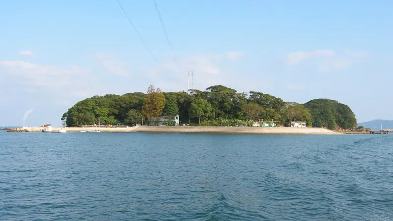
A historic island in Usuki Bay where the Liefde ship landed, featuring monuments to William Adams and a swimming beach.
What it is
- A small island in Usuki Bay measuring three kilometers in circumference.
- The landing site of the ship Liefde on April 19, 1600.
- Part of the Nippo Kaigan Quasi-National Park system.
- Home to the Miura Anjin Memorial Park dedicated to William Adams.
What to see
- A statue of Jan Joosten, a crew member of the Liefde.
- The Miura Anjin Memorial Park commemorating the first Englishman in Japan.
- A swimming beach and a campsite for outdoor recreation.
- Views of the surrounding Nippo Kaigan Quasi-National Park.
Getting there
- Take a ferry from Sashiu Fishing Port to reach the island.
- The ferry crossing takes approximately three to five minutes.
04
Jiguro Island
ŌITA · PLACE 地黒島
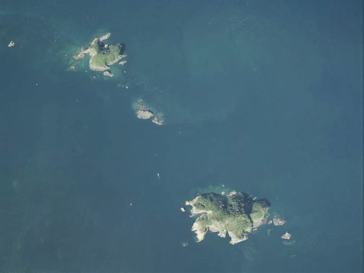
An uninhabited island in Oita Prefecture known for its protected natural environment and excellent fishing for black sea bream.
What it is
- An uninhabited island located off the coast of Yonozu Bay in Saiki City.
- Part of a pair of islands collectively known as Kuroshima.
- Designated as a quasi-national park special protection zone.
- A location formerly divided between Yonozu Village and Kamae Town.
What to see
- Surrounding waters populated by black sea bream and largescale blackfish.
- The neighboring Okiguro Island located one kilometer to the southeast.
- A reef named Chotabae situated between the island and Kishimegi Cape.
Getting there
- Access is available only via private charter or ferry boats.
- No scheduled ferry service exists for this uninhabited location.
05
Hotojima
ŌITA · PLACE 保戸島

A dense fishing village on a small island known for its unique three-story concrete houses built on steep coastal slopes.
What it is
- A small island in the Bungo Channel serving as a base for deep-sea tuna fishing.
- A designated historic cultural asset of fishing located within Nippo Kaigan Quasi-National Park.
- A compact settlement with a circumference of only four kilometers and steep terrain.
What to see
- Three-story concrete buildings standing closely together on the steep coastal slopes.
- Mount Tomi which reaches one hundred and seventy-nine meters above sea level.
- Oita Prefectural Road 612 which narrows to a minimum width of only 1.2 meters.
Getting there
- Regular boats depart from Tsukumi Port for the twenty-five minute journey to the island.
06
Ōshima
ŌITA · PLACE 大島

A quiet island in Oita featuring a 400-year-old banyan tree and scenic views within a quasi-national park.
What it is
- A small island in Saiki City also known as Bungo Oshima
- The island covers an area of 1.63 square kilometers
- Home to a small local population of eighty-five people
- The eastern coast belongs to the Nippo Kaigan Quasi-National Park
What to see
- A four-hundred-year-old banyan tree designated as a prefectural natural monument
- The highest point on the island reaching one hundred and ninety-three meters
- Scenic coastal views located six hundred meters north of Tsurumisaki
Getting there
- Take a regular ferry from Saiki Katsu Port to the island
- The ferry journey takes approximately thirty to forty minutes
07
Mizunokojima
ŌITA · PLACE 水ノ子島
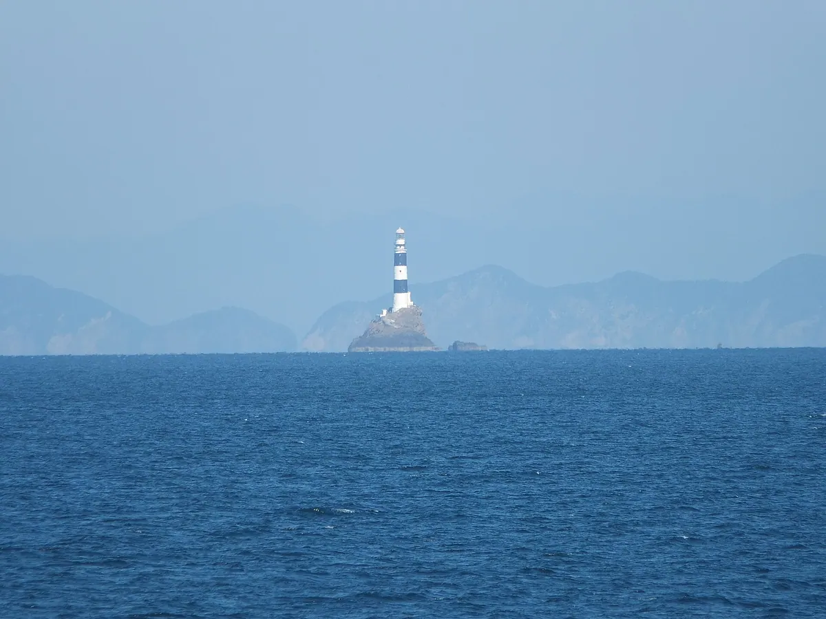
An uninhabited island in the Bungo Channel featuring a historic lighthouse and popular spots for rock fishing.
What it is
- An uninhabited island in the Bungo Channel belonging to Saiki City.
- A small landmass with a circumference of 300 meters and 20 meters height.
- A protected area within the Nippo Kaigan Quasi-National Park.
- The site of a lighthouse that was fully automated in 1986.
What to see
- The Mizunokojima Lighthouse standing on the rocky island terrain.
- Coastal views of the Bungo Channel from the surrounding waters.
- Rock fishing spots utilized by local anglers in the area.
When to go
- Summer weekends when cruise ships operate around the island.
- Daylight hours to view the lighthouse from a passing vessel.
08
Tsukumi Island
ŌITA · PLACE 津久見島
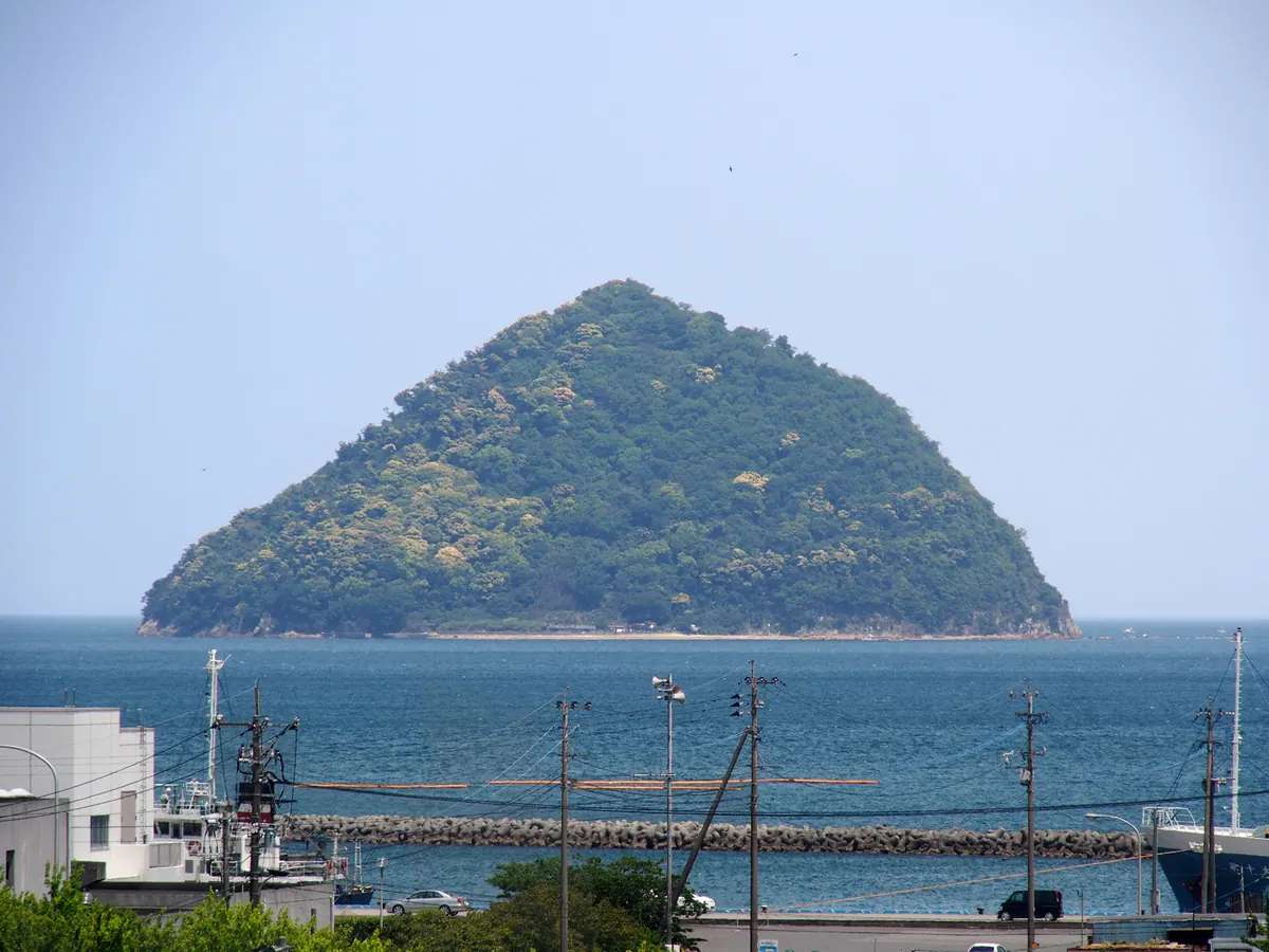
An uninhabited island in Oita known for its subtropical forests, a historic shrine, and a nickname inspired by its shape.
What it is
- An uninhabited island in Usuki Bay covering zero point two square kilometers.
- Part of the Nippo Kaigan Quasi-National Park with the nickname Onigiri Island.
- Lord Inaba Kazumichi enshrined the deity Benzaiten here in 1624.
- The entire island is covered in subtropical virgin forests.
What to see
- A swimming beach and campsite located on the mainland side.
- The habitat of the Graphium doson butterfly, a prefectural natural monument.
- Dolphins occasionally visible in the waters surrounding the island.
- The highest point of the island reaching one hundred sixty-six meters.
09
Tsutashima
ŌITA · PLACE 蔦島

An uninhabited island in Nippo Kaigan Quasi-National Park known for its sea cliffs, ivy, and crystalline schist terrain.
What it is
- An uninhabited island located off the coast of the Saganoseki Peninsula in Oita City.
- Part of the Nippo Kaigan Quasi-National Park featuring a central coastal terrace.
- A small island covering 0.04 square kilometers with a peak of 64.4 meters.
- Named for the ivy that grows there and also known as Maenoshima.
What to see
- Natural terrain consisting of crystalline schist and steep sea cliffs.
- A third-class triangulation point installed at the island's highest elevation.
- Coastal landscapes that have been documented since the historical Dazaikannai-shi records.